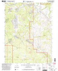
2001 Map of Bull Mountain
USGS Topo · Published 2004About this map
Gunnison National Forest land defines this high-altitude landscape, where the seasonal rhythms of ranching are marked by several isolated outposts. Seasonal operations such as Cockroft Cow Camp and Hotchkiss Sheep Camp indicate the enduring agricultural use of the mountainous terrain. Water management is central to the area's utility, evidenced by the presence of Aspen Leaf Reservoir and Ault Reservoir, which capture runoff from the surrounding peaks.
Find a feature on this map
30 named features on this map. Tap any name to fly to it.
Don’t see what you’re looking for? This feature index may not catch every label — zoom into the map to look around manually.
Map Details
Editions of this 2001 Bull Mountain Map
This is the sole edition of this map. No revisions or reprints were ever made.
Other maps of this area

1938 · Mt. Gunnison
USGS Topo · 1:48,000

1945 · Mount Gunnison
USGS Topo · 1:62,500

1956 · Montrose
USGS Topo · 1:250,000

1957 · Leadville
USGS Topo · 1:250,000

1959 · Leadville
USGS Topo · 1:250,000

1959 · Montrose
USGS Topo · 1:250,000

1960 · Leadville
USGS Topo · 1:250,000

1960 · Montrose
USGS Topo · 1:250,000

1961 · Electric Mountain
USGS Topo · 1:24,000

1961 · Spruce Mountain
USGS Topo · 1:24,000