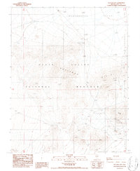
1986 Map of Bullfrog Mtn.
USGS Topo · Published 1986About this map
Bullfrog Hills mining history is etched into the landscape of this mid-1980s survey, showing a network of industrial extraction in the high desert of Nye County. The prominent Original Bullfrog Mine and the Gold Bar site stand as markers of the area's rich mineral heritage near Bullfrog Mtn. Across the arid expanse, an Old RR Grade traces the path of former rail transport that once connected these remote mining camps to the wider world.
Find a feature on this map
17 named features on this map. Tap any name to fly to it.
Don’t see what you’re looking for? This feature index may not catch every label — zoom into the map to look around manually.
Map Details
Editions of this 1986 Bullfrog Mtn. Map
This is the sole edition of this map. No revisions or reprints were ever made.
Other maps of this area

1908 · Kawich
USGS Topo · 1:250,000

1908 · Lida
USGS Topo · 1:250,000

1908 · Furnace Creek
USGS Topo · 1:250,000

1908 · Ballarat
USGS Topo · 1:250,000

1910 · Furnace Creek
USGS Topo · 1:250,000

1913 · Lida
USGS Topo · 1:250,000

1913 · Ballarat
USGS Topo · 1:250,000

1942 · Tolicha Peak
USGS Topo · 1:125,000

1942 · Bullfrog
USGS Topo · 1:125,000

1948 · Death Valley
USGS Topo · 1:250,000