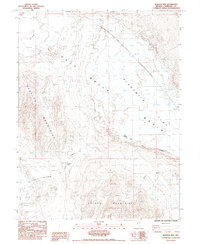
1985 Map of Bunejug Mts.
USGS Topo · Published 1985About this map
The Pony Express Route cuts across this high desert landscape, a historical corridor preserved in a mid-1980s topographic study. This segment of Churchill County is defined by the massive, arid sinks of Eightmile Flat, Salt Wells Basin, and Star Flat, where the water table is marked by infrequent reliable points like Salt Wells and Lattin Well. The terrain is anchored by the Bunejug Mountains to the west and the Cocoon Mountains to the south, with the Pony Express Monument standing as a sentinel at Simpson Pass. The geography suggests a difficult transit for early travelers, relying on scattered water sources such as Rock Springs and Allen Springs. Modern industrial interests are hinted at by the presence of a Geothermal Well and several Borrow Pits, showing how the land's utility evolved from a 19th-century mail route to 20th-century resource extraction.
Find a feature on this map
23 named features on this map. Tap any name to fly to it.
Don’t see what you’re looking for? This feature index may not catch every label — zoom into the map to look around manually.
Map Details
Editions of this 1985 Bunejug Mts. Map
This is the sole edition of this map. No revisions or reprints were ever made.
Other maps of this area

1908 · Carson Sink
USGS Topo · 1:250,000

1910 · Carson Sink
USGS Topo · 1:250,000

1951 · Carson Lake
USGS Topo · 1:62,500

1951 · Allen Springs
USGS Topo · 1:62,500

1957 · Reno
USGS Topo · 1:250,000

1959 · Reno
USGS Topo · 1:250,000

1960 · Reno
USGS Topo · 1:250,000

1972 · Fourmile Flat
USGS Topo · 1:24,000

1972 · Diamond Canyon
USGS Topo · 1:24,000

1979 · Fallon
USGS Topo · 1:100,000