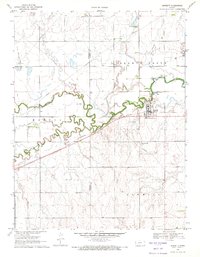
1970 Map of Burdett
USGS Topo · Published 1971About this map
Burdett serves as the primary hub in this western Kansas landscape, situated at the junction of the Atchison Topeka and Santa Fe railroad and the Pawnee River. The map illustrates a region defined by its watercourses and transport infrastructure during the early 1970s, with Dry Creek and Buckner Creek feeding into the meandering river system. Evidence of local aviation is present at the Burdett Community Airport and the smaller Rucker Airport nearby.
Find a feature on this map
14 named features on this map. Tap any name to fly to it.
Don’t see what you’re looking for? This feature index may not catch every label — zoom into the map to look around manually.
Map Details
Editions of this 1970 Burdett Map
This is the sole edition of this map. No revisions or reprints were ever made.
Other maps of this area

1889 · Larned
USGS Topo · 1:125,000

1891 · Larned
USGS Topo · 1:125,000

1892 · Ness
USGS Topo · 1:125,000

1894 · Ness
USGS Topo · 1:125,000

1955 · Great Bend
USGS Topo · 1:250,000

1957 · Great Bend
USGS Topo · 1:250,000

1958 · Great Bend
USGS Topo · 1:250,000
1970 · Hanston
USGS Topo · 1:24,000

1970 · Hanston NW
USGS Topo · 1:24,000
1970 · Rozel
USGS Topo · 1:24,000