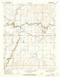
1970 Map of Rozel
USGS Topo · Published 1971About this map
Rozel serves as the central hub of this agricultural landscape in Pawnee County, situated where the Atchison Topeka and Santa Fe railroad crosses the plains. The town is marked by its grid of streets, the Rozel Cem to the south, and a series of Sewage Disposal Ponds that indicate mid-century municipal infrastructure. The terrain is defined by the winding course of the Pawnee River and Sawmill Creek, which carve distinct paths through the surrounding township divisions. To the northwest, the Buckman Landing Field provides a look at local aviation history, while the Brick Sch and various labeled wells throughout the township boundaries of Browns Grove, Grant, and Sawmill reflect the established rural community and water management needs of the early 1970s.
Find a feature on this map
14 named features on this map. Tap any name to fly to it.
Don’t see what you’re looking for? This feature index may not catch every label — zoom into the map to look around manually.
Map Details
Editions of this 1970 Rozel Map
This is the sole edition of this map. No revisions or reprints were ever made.
Other maps of this area

1889 · Larned
USGS Topo · 1:125,000

1891 · Larned
USGS Topo · 1:125,000

1892 · Ness
USGS Topo · 1:125,000

1894 · Ness
USGS Topo · 1:125,000

1955 · Great Bend
USGS Topo · 1:250,000

1957 · Great Bend
USGS Topo · 1:250,000

1958 · Great Bend
USGS Topo · 1:250,000
1970 · Sanford
USGS Topo · 1:24,000
1970 · Burdett
USGS Topo · 1:24,000
1970 · Rush Center SW
USGS Topo · 1:24,000