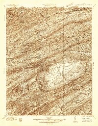
1936 Map of Burkes Garden
USGS Topo · Published 1936About this map
Burkes Garden dominates the southeastern quadrant of this survey, appearing as a singular limestone basin completely encircled by Garden Mountain. This distinctive geological bowl is a center of local settlement, featuring Station Spring, Fish Spring, and Blue Spring as primary water sources. Further north, the landscape shifts into the ridge-and-valley patterns of the Appalachian Highlands, where the Clinch River and Bluestone River systems originate. Industrial activity is visible near the West Virginia border, where the Norfolk and Western RR serves the growing communities of Bluefield and West Graham. The interior valleys are dotted with small rural hubs like Witten Mill and Shawver Mill, along with numerous community landmarks such as Ebenezer Ch and Sluss Sch, reflecting the agricultural and social structure of Tazewell County during the mid-1930s.
Find a feature on this map
68 named features on this map. Tap any name to fly to it.
Don’t see what you’re looking for? This feature index may not catch every label — zoom into the map to look around manually.
Map Details
Editions of this 1936 Burkes Garden Map
This is the sole edition of this map. No revisions or reprints were ever made.
Other maps of this area

1887 · Pocahontas
USGS Topo · 1:125,000

1889 · Wytheville
USGS Topo · 1:125,000

1891 · Tazewell
USGS Topo · 1:125,000

1891 · Pocahontas
USGS Topo · 1:125,000

1891 · Abingdon
USGS Topo · 1:125,000

1892 · Wytheville
USGS Topo · 1:125,000

1894 · Pocahontas
USGS Topo · 1:125,000

1894 · Abingdon
USGS Topo · 1:125,000

1895 · Tazewell
USGS Topo · 1:125,000

1895 · Pocahontas
USGS Topo · 1:125,000