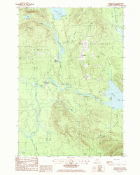
1988 Map of Burlington
USGS Topo · Published 1988About this map
Burlington sits at the center of this Maine landscape, defined by a network of glacial ponds and narrow waterways in Penobscot County. The community of Lowell and the nearby East Lowell are connected by a series of brooks and streams, including the winding Gristmill Stream and Buck Brook. Notable water bodies such as Eskutassis Pond and Saponac Pond dominate the northern and eastern portions of the map, while the Pasadumkeag River flows through the central valley, punctuated by features like White Horse Rips and The Narrows.
Find a feature on this map
42 named features on this map. Tap any name to fly to it.
Don’t see what you’re looking for? This feature index may not catch every label — zoom into the map to look around manually.
Map Details
Editions of this 1988 Burlington Map
This is the sole edition of this map. No revisions or reprints were ever made.
Other maps of this area

1917 · Passadumkeag
USGS Topo · 1:62,500

1920 · Winn
USGS Topo · 1:62,500

1931 · Saponac
USGS Topo · 1:48,000

1934 · Saponac
USGS Topo · 1:62,500

1942 · Lincoln
USGS Topo · 1:62,500

1954 · Millinocket
USGS Topo · 1:250,000

1957 · Lincoln
USGS Topo · 1:62,500

1957 · Saponac
USGS Topo · 1:62,500

1958 · Millinocket
USGS Topo · 1:250,000

1960 · Millinocket
USGS Topo · 1:250,000