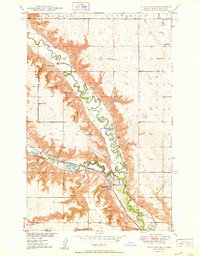
1950 Map of Burlington
USGS Topo · Published 1950About this map
The confluence of the Souris River and the Des Lacs River anchors this Ward County landscape during a period of significant agricultural and water-management development. In the mid-twentieth century, the town of Burlington sits at the heart of a complex transport network where the Minneapolis St Paul and Sault Ste Marie and Great Northern railroads converge. The map reveals an intricate system of land use, from the managed flow of an Irrigation Ditch and its Pump Station to the scattered educational centers of School No 2, School No 4, and Graham Sch. Beyond the valley floors, the topography is defined by drainage features like Lloyds Coulee and Larsons Coulee, which cut through the townships of Saint Marys, Waterford, and Burlington. Cultural markers such as the Evangelical Church and the Minot Country Club highlight the community's established social infrastructure.
Find a feature on this map
21 named features on this map. Tap any name to fly to it.
Don’t see what you’re looking for? This feature index may not catch every label — zoom into the map to look around manually.
Map Details
Editions of this 1950 Burlington Map
This is the sole edition of this map. No revisions or reprints were ever made.
Other maps of this area

1928 · Minot
USGS Topo · 1:62,500

1948 · Burlington
USGS Topo · 1:24,000

1948 · Burlington
USGS Topo · 1:62,500

1948 · Minot NW
USGS Topo · 1:24,000

1949 · Burlington NW
USGS Topo · 1:24,000

1949 · Minot NW
USGS Topo · 1:24,000

1949 · Carpio NE
USGS Topo · 1:24,000

1949 · Burlington SE
USGS Topo · 1:24,000

1949 · Minot
USGS Topo · 1:24,000
1949 · Burlington NE
USGS Topo · 1:24,000