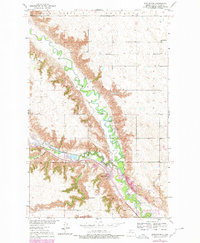
1948 Map of Burlington
USGS Topo · Published 1980About this map
Burlington serves as the focal point of this North Dakota landscape, situated at the confluence where the Des Lacs River joins the meandering Souris River. The topography is defined by the deep valley cut through the plains, with complex coulees like Larsons Coulee carving into the surrounding uplands. A 1979 photorevision of the original 1948 survey shows the development of the Minot Country Club and infrastructure like the Pump Sta and Irrigation Ditch, reflecting the management of water resources in this prairie environment. Transportation and community life are anchored by the Burlington Northern railroad and rural institutions including School No 2 and the Evangelical Ch. The map provides a detailed record of land use and civil boundaries across the townships of Waterford, Kirkelie, and Eureka.
Find a feature on this map
18 named features on this map. Tap any name to fly to it.
Don’t see what you’re looking for? This feature index may not catch every label — zoom into the map to look around manually.
Map Details
Editions of this 1948 Burlington Map
2 editions found
Other maps of this area

1928 · Minot
USGS Topo · 1:62,500

1948 · Burlington
USGS Topo · 1:24,000

1948 · Burlington
USGS Topo · 1:62,500

1948 · Minot NW
USGS Topo · 1:24,000

1949 · Burlington NW
USGS Topo · 1:24,000

1949 · Minot NW
USGS Topo · 1:24,000

1949 · Carpio NE
USGS Topo · 1:24,000

1949 · Burlington SE
USGS Topo · 1:24,000

1949 · Minot
USGS Topo · 1:24,000
1949 · Burlington NE
USGS Topo · 1:24,000