
1948 Map of Burlington
USGS Topo · Published 1948About this map
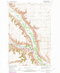
The confluence of the Souris River and Des Lacs River dominates this mid-century landscape, where the town of Burlington sits at the junction of two major rail lines. Surveyed as part of the Missouri River Basin development program, the map details a region defined by steep coulees and river valleys cutting through the surrounding plateaus of Saint Marys and Waterford.
Find a feature on this map
21 named features on this map. Tap any name to fly to it.
Don’t see what you’re looking for? This feature index may not catch every label — zoom into the map to look around manually.
Map Details
Editions of this 1948 Burlington Map
2 editions found
Other maps of this area

1928 · Minot
USGS Topo · 1:62,500

1948 · Burlington
USGS Topo · 1:62,500

1948 · Minot NW
USGS Topo · 1:24,000

1949 · Burlington NW
USGS Topo · 1:24,000

1949 · Minot NW
USGS Topo · 1:24,000

1949 · Carpio NE
USGS Topo · 1:24,000

1949 · Burlington SE
USGS Topo · 1:24,000

1949 · Minot
USGS Topo · 1:24,000
1949 · Burlington NE
USGS Topo · 1:24,000

1950 · Des Lacs
USGS Topo · 1:24,000