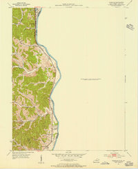
1953 Map of Burnaugh
USGS Topo · Published 1956About this map
The Big Sandy River defines the eastern boundary of Boyd County in this mid-century survey, separating the Kentucky hills from West Virginia. The Chesapeake and Ohio railroad hugs the riverbank, serving riverfront settlements like Burnaugh and Leach Station. Inland, the landscape is carved by numerous drainages such as Durbin Creek and Whites Creek, where small communities and family-named landmarks are concentrated. Local life in the early 1950s is anchored by institutions like Whites Creek Ch and the Durbin Sch. The map reveals a high density of small family burial grounds, including Lockwood Cem, Bryants Cem, and Hacker Cem, which are essential for genealogists tracing the inhabitants of these hollows. The presence of a Radio Station near the river reflects the era's modern communication infrastructure amidst a traditional agricultural and industrial landscape.
Find a feature on this map
34 named features on this map. Tap any name to fly to it.
Don’t see what you’re looking for? This feature index may not catch every label — zoom into the map to look around manually.
Map Details
Editions of this 1953 Burnaugh Map
This is the sole edition of this map. No revisions or reprints were ever made.
Other maps of this area

1892 · Huntington
USGS Topo · 1:125,000

1898 · Huntington
USGS Topo · 1:125,000

1901 · Guyandot
USGS Topo · 1:62,500

1901 · Ceredo
USGS Topo · 1:62,500

1902 · Guyandot
USGS Topo · 1:62,500

1903 · Kenova
USGS Topo · 1:125,000

1904 · Kenova
USGS Topo · 1:125,000

1909 · Wayne
USGS Topo · 1:62,500

1911 · Louisa
USGS Topo · 1:48,000

1913 · Ceredo
USGS Topo · 1:62,500