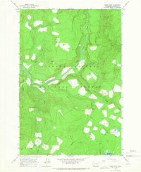
1965 Map of Burnt Peak
USGS Topo · Published 1966About this map
The Gifford Pinchot National Forest dominates this mid-1960s terrain, where the Lewis River and Muddy River converge amidst a network of high-elevation landmarks. This wilderness survey focuses on the rugged timberland of Skamania County, anchored by Burnt Peak Lookout 4106 and the sharp relief of the Crazy Hills. The map details a landscape managed for both utility and recreation, featuring several Gaging Stations along the watercourses and the Curly Creek Campground for visitors.
Find a feature on this map
31 named features on this map. Tap any name to fly to it.
Don’t see what you’re looking for? This feature index may not catch every label — zoom into the map to look around manually.
Map Details
Editions of this 1965 Burnt Peak Map
This is the sole edition of this map. No revisions or reprints were ever made.
Other maps of this area

1919 · Mount St Helens
USGS Topo · 1:125,000

1926 · Steamboat Mtn
USGS Topo · 1:125,000

1926 · Hood River
USGS Topo · 1:125,000

1929 · Hood River
USGS Topo · 1:125,000

1931 · Steamboat Mtn
USGS Topo · 1:125,000

1940 · Lookout Mtn
USGS Topo · 1:62,500

1948 · Vancouver
USGS Topo · 1:250,000

1950 · Vancouver
USGS Topo · 1:250,000

1950 · Vancouver
USGS Topo · 1:250,000

1950 · Yakima
USGS Topo · 1:250,000