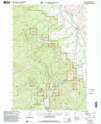
1998 Map of Burnt Ridge
USGS Topo · Published 2002About this map
The Bitterroot National Forest dominates this Montana landscape, where the Bitterroot River and West Fork Bitterroot River converge. The settlement of Conner and the Trapper Creek Job Corps Center mark the primary areas of human activity along the river valleys, contrasted by the steep elevations of Burnt Ridge and Baker Point. This 1990s revision reveals a managed wilderness, balancing public land infrastructure like the Ranger District and an Electronic Site with the area's hydrology. Waterways such as Tin Cup Creek, Chaffin Creek, and Trapper Creek feed the main river system, while local industrial traces are found at a Gravel Pit near the East Fork Road. The inclusion of land features like Hart Bench and Grouse Butte highlights the transition from agricultural river bottoms to the timbered reaches of the Bitterroot range.
Find a feature on this map
37 named features on this map. Tap any name to fly to it.
Don’t see what you’re looking for? This feature index may not catch every label — zoom into the map to look around manually.
Map Details
Editions of this 1998 Burnt Ridge Map
This is the sole edition of this map. No revisions or reprints were ever made.
Other maps of this area

1901 · Hamilton
USGS Topo · 1:125,000

1956 · Elk City
USGS Topo · 1:250,000

1956 · Hamilton
USGS Topo · 1:250,000

1959 · Hamilton
USGS Topo · 1:250,000

1960 · Elk City
USGS Topo · 1:250,000

1960 · Hamilton
USGS Topo · 1:250,000

1964 · Hamilton
USGS Topo · 1:250,000

1964 · Burnt Ridge
USGS Topo · 1:24,000

1964 · Boulder Peak
USGS Topo · 1:24,000

1964 · Darby
USGS Topo · 1:24,000