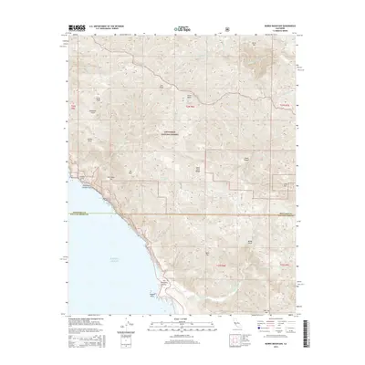
2015 Map of Burro Mountain
USGS Topo · Published 2015About this map
Ragged Point serves as a prominent coastal landmark where the steep slopes of the Santa Lucia Range meet the Pacific Ocean. This 2015 survey details the vertical landscape of the Los Padres National Forest, a region defined by sharp ridgelines like Thorndyke Top and Salmon Head that separate deep drainages. The map captures the boundary between Monterey and San Luis Obispo counties, highlighting the transition from high peaks such as Burro Mtn down to the San Carpoforo Valley. Within these canyons, numerous seasonal and perennial watercourses flow toward the coast, including Villa Cr, Salmon Cr, and San Carpoforo Cr. Small local features like School Spring and White Rock Number One offer specific points of interest for those tracing the more remote corners of the Central Coast, while summits like Mt Mars and Lion Peak dominate the interior topography.
Find a feature on this map
38 named features on this map. Tap any name to fly to it.
Don’t see what you’re looking for? This feature index may not catch every label — zoom into the map to look around manually.
Map Details
Editions of this 2015 Burro Mountain Map
This is the sole edition of this map. No revisions or reprints were ever made.
Other maps of this area

1919 · Bryson
USGS Topo · 1:62,500

1919 · Piedras Blancas
USGS Topo · 1:62,500

1919 · San Simeon
USGS Topo · 1:62,500

1921 · Cape San Martin
USGS Topo · 1:62,500

1927 · Piedras Blancas
USGS Topo · 1:62,500

1937 · San Simeon
USGS Topo · 1:62,500

1941 · Cape San Martin
USGS Topo · 1:62,500

1941 · Bryson
USGS Topo · 1:62,500

1942 · Bryson
USGS Topo · 1:62,500

1942 · Cape San Martin
USGS Topo · 1:62,500