
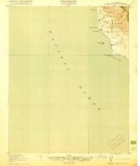
1919 Map of Piedras Blancas
USGS Topo · Published 1919About this map
The rugged shoreline of San Luis Obispo County is defined by prominent coastal landmarks in this 1917 survey, most notably the Lh at Piedras Blancas Point. This maritime orientation is reinforced by distinctive offshore features such as Harlech Castle Rock, Breaker Pt, and La Cruz Rock. The map illustrates the coastal interface where steep drainages like Arroyo de la Cruz and Arroyo de los Chinos meet the Pacific Ocean, cutting through the coastal terrace from the interior heights of Pine Top Mtn.
Find a feature on this map
16 named features on this map. Tap any name to fly to it.
Don’t see what you’re looking for? This feature index may not catch every label — zoom into the map to look around manually.
Map Details
Editions of this 1919 Piedras Blancas Map
2 editions found
Other maps of this area

1919 · Bryson
USGS Topo · 1:62,500

1919 · San Simeon
USGS Topo · 1:62,500

1921 · Cape San Martin
USGS Topo · 1:62,500

1927 · Piedras Blancas
USGS Topo · 1:62,500

1937 · San Simeon
USGS Topo · 1:62,500

1941 · Cape San Martin
USGS Topo · 1:62,500

1941 · Bryson
USGS Topo · 1:62,500

1942 · Bryson
USGS Topo · 1:62,500

1942 · Cape San Martin
USGS Topo · 1:62,500

1947 · San Luis Obispo
USGS Topo · 1:250,000