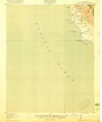
1919 Map of Piedras Blancas
USGS Topo · Published 1919About this map
The rugged shoreline of Piedras Blancas Point dominates this 1917 coastal survey, where the terrestrial world meets the vast Pacific Ocean. Along this remote stretch of San Luis Obispo County, the landscape is defined by dramatic sea stacks such as Harlech Castle Rock and La Cruz Rock. Inland, the terrain rises sharply toward Pine Top Mtn, cut by numerous drainage systems including Arroyo de la Cruz and Arroyo de los Chinos. The presence of the Washington School near the coast indicates a small, established community serving the families of lighthouse keepers and local ranchers during this era. A lighthouse, marked simply as LH, stands as a critical navigational sentinel on the point, anchoring a maritime corridor that saw significant naval and merchant activity in the years following the Great War.
Find a feature on this map
16 named features on this map. Tap any name to fly to it.
Don’t see what you’re looking for? This feature index may not catch every label — zoom into the map to look around manually.
Map Details
Editions of this 1919 Piedras Blancas Map
2 editions found
Other maps of this area

1919 · Bryson
USGS Topo · 1:62,500

1919 · Piedras Blancas
USGS Topo · 1:62,500

1919 · San Simeon
USGS Topo · 1:62,500

1921 · Cape San Martin
USGS Topo · 1:62,500

1927 · Piedras Blancas
USGS Topo · 1:62,500

1937 · San Simeon
USGS Topo · 1:62,500

1941 · Cape San Martin
USGS Topo · 1:62,500

1941 · Bryson
USGS Topo · 1:62,500

1942 · Bryson
USGS Topo · 1:62,500

1942 · Cape San Martin
USGS Topo · 1:62,500