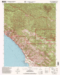
1995 Map of Burro Mountain
USGS Topo · Published 2000About this map
The Santa Lucia Range dominates this coastal landscape where the Silver Peak Wilderness meets the Pacific Ocean. This survey reveals a terrain defined by steep drainage basins and remote outposts, such as the Baldwin Ranch and several backcountry locations like the Lion Den Campsite and Turkey Springs Campsite. The presence of the Polar Star Mine near San Carpoforo Creek indicates the area's history of mineral exploration, while the northern boundary is shared with the Fort Hunter Liggett military reservation.
Find a feature on this map
39 named features on this map. Tap any name to fly to it.
Don’t see what you’re looking for? This feature index may not catch every label — zoom into the map to look around manually.
Map Details
Editions of this 1995 Burro Mountain Map
This is the sole edition of this map. No revisions or reprints were ever made.
Other maps of this area

1919 · Bryson
USGS Topo · 1:62,500

1919 · Piedras Blancas
USGS Topo · 1:62,500

1919 · San Simeon
USGS Topo · 1:62,500

1921 · Cape San Martin
USGS Topo · 1:62,500

1927 · Piedras Blancas
USGS Topo · 1:62,500

1937 · San Simeon
USGS Topo · 1:62,500

1941 · Cape San Martin
USGS Topo · 1:62,500

1941 · Bryson
USGS Topo · 1:62,500

1942 · Bryson
USGS Topo · 1:62,500

1942 · Cape San Martin
USGS Topo · 1:62,500