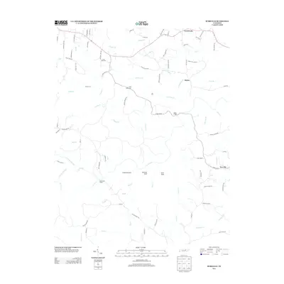
2013 Map of Burrville
USGS Topo · Published 2013About this map
Burrville and the surrounding plateau of Fentress County are defined by a network of deep-cut drainage and traditional crossing points. The landscape is structured by the Clear Fork and its numerous tributaries, including Crooked Cr and Skull Cave Cr, which dictate the placement of early infrastructure. Key river access points like Howard Ford and Key Ford indicate long-standing transit routes across the waterways, while more modern crossings such as Peters Bridge and Gatewood Bridge represent later engineering.
Find a feature on this map
87 named features on this map. Tap any name to fly to it.
Don’t see what you’re looking for? This feature index may not catch every label — zoom into the map to look around manually.
Map Details
Editions of this 2013 Burrville Map
This is the sole edition of this map. No revisions or reprints were ever made.
Other maps of this area

1895 · Wartburg
USGS Topo · 1:125,000

1896 · Wartburg
USGS Topo · 1:125,000

1935 · Pilot Mountain
USGS Topo · 1:24,000

1936 · Twin Bridges
USGS Topo · 1:24,000

1936 · Jones Knob
USGS Topo · 1:24,000

1943 · Twin Bridges
USGS Topo · 1:24,000
1945 · Twin Bridges
USGS Topo · 1:24,000
1946 · Pilot Mountain
USGS Topo · 1:24,000
1949 · Jones Knob
USGS Topo · 1:24,000

1952 · Honey Creek
USGS Topo · 1:24,000