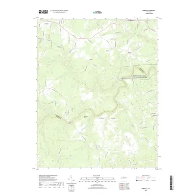
2019 Map of Burrville
USGS Topo · Published 2019About this map
Allardt and Burrville anchor the high plateaus of Fentress County, where the landscape is defined by the deep incisions of the Clear Fork and its tributaries. The terrain transitions from the settled agricultural lands near Armathwaite and Shirley into the protected wilderness of the Big South Fork National River and Recreation Area. Historical routes such as Rugby Pike and the Old Turnpike Rd trace the ridges, while family names are preserved on the land through landmarks like Galloway Knob and the Wright Cem. The convergence of the North Prong Clear Fork and S Prong Clear Fork creates a complex system of bluffs and narrow valleys, including the distinctive Underwood Neck. These topographical features dictated the placement of early infrastructure, such as the Gatewood Bridge and numerous ford crossings that connected isolated homesteads in the Cumberland Plateau.
Find a feature on this map
82 named features on this map. Tap any name to fly to it.
Don’t see what you’re looking for? This feature index may not catch every label — zoom into the map to look around manually.
Map Details
Editions of this 2019 Burrville Map
This is the sole edition of this map. No revisions or reprints were ever made.
Other maps of this area

1895 · Wartburg
USGS Topo · 1:125,000

1896 · Wartburg
USGS Topo · 1:125,000

1935 · Pilot Mountain
USGS Topo · 1:24,000

1936 · Twin Bridges
USGS Topo · 1:24,000

1936 · Jones Knob
USGS Topo · 1:24,000

1943 · Twin Bridges
USGS Topo · 1:24,000
1945 · Twin Bridges
USGS Topo · 1:24,000
1946 · Pilot Mountain
USGS Topo · 1:24,000
1949 · Jones Knob
USGS Topo · 1:24,000

1952 · Honey Creek
USGS Topo · 1:24,000