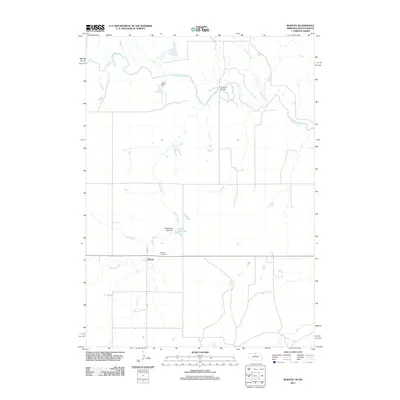
2011 Map of Burton
USGS Topo · Published 2011About this map
Burton stands as a quiet prairie settlement in north-central Nebraska, positioned just south of the South Dakota border. The landscape is defined by the winding course of the Keya Paha River, which cuts across the northern reaches of the area, joined by tributaries like Lute Creek and Buffalo Creek. This 2011 survey documents the rural character of Keya Paha County, where long-established landmarks like the Burton Cemetery and local water management features such as Nilson Dam anchor the community. The drainage patterns of Burton Creek flow southward through the plains, while the Eagles Nest Lake Dam and its accompanying Eagles Nest Lake provide a rare open water feature in this agricultural region. This map illustrates the intersection of small-town Nebraska life with the essential water sources that dictate the viability of the high plains landscape.
Find a feature on this map
10 named features on this map. Tap any name to fly to it.
Don’t see what you’re looking for? This feature index may not catch every label — zoom into the map to look around manually.
Map Details
Editions of this 2011 Burton Map
This is the sole edition of this map. No revisions or reprints were ever made.
Other maps of this area

1949 · Jamison SW
USGS Topo · 1:24,000

1951 · Jamison SW
USGS Topo · 1:24,000

1955 · Mitchell
USGS Topo · 1:250,000

1955 · O'Neill
USGS Topo · 1:250,000

1959 · O'Neill
USGS Topo · 1:250,000

1959 · Mitchell
USGS Topo · 1:250,000

1964 · Dallas SW
USGS Topo · 1:24,000

1964 · Mills
USGS Topo · 1:24,000
1964 · Springview
USGS Topo · 1:24,000

1964 · Paxton
USGS Topo · 1:24,000