1981 Map of Butler
USGS Topo · Published 1981About this map
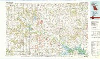
The Marais des Cygnes River winds through this borderland region where the agricultural plains of eastern Kansas meet western Missouri. In the early 1980s, the landscape was a complex network of river bottoms and managed wetlands, including the extensive Marais des Cygnes Waterfowl Area and the Schell-Osage State Wildlife Area. This era saw the significant impact of the Harry S. Truman Reservoir on the southeastern corner of the map, reshaping the drainage of the Osage River. Industrial activity is evident through numerous Strip Mines scattered near the state line, while transportation was anchored by a robust rail system including the Missouri Pacific and Kansas City Southern. Smaller settlements like Trading Post and Lacygne reflect the area's deep history, which is officially commemorated at the Massacre Memorial State Park.
Find a feature on this map
94 named features on this map. Tap any name to fly to it.
Don’t see what you’re looking for? This feature index may not catch every label — zoom into the map to look around manually.
Map Details
Editions of this 1981 Butler Map
This is the sole edition of this map. No revisions or reprints were ever made.
Other maps of this area

1884 · Fort Scott
USGS Topo · 1:125,000

1885 · Garnett
USGS Topo · 1:125,000

1885 · Warrensburg
USGS Topo · 1:125,000

1885 · Lawrence
USGS Topo · 1:125,000

1886 · Nevada
USGS Topo · 1:125,000

1886 · Stockton
USGS Topo · 1:125,000

1886 · Iola
USGS Topo · 1:125,000

1886 · Fort Scott
USGS Topo · 1:125,000

1887 · Clinton
USGS Topo · 1:125,000

1887 · Harrisonville
USGS Topo · 1:125,000