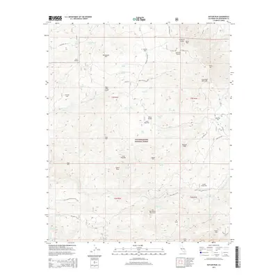
2015 Map of Butler Peak
USGS Topo · Published 2015About this map
Butler Peak and the high elevations of the San Bernardino National Forest dominate this 2015 survey, revealing a landscape defined by its network of high-altitude flats and vital water sources. The map traces the winding route of the Pacific Crest National Scenic Trail as it traverses the southern section of the quadrangle, passing through the San Bernardino Mountains near Crafts Peak. This region is characterized by numerous seasonal and perennial springs, such as Snow Slide Spring, Dishpan Spring, and Lightning Spring, which have historically supported local flora and fauna. Notable terrain features like Big Pine Flat and Little Pine Flat break up the mountain ridges, while prominent summits including Rattlesnake Mtn and Shay Mtn provide significant landmarks. This edition documents the modern forest service road system, including 3N17 Forest Svc Rd and Coxey Rd, which provide access to these remote reaches.
Find a feature on this map
70 named features on this map. Tap any name to fly to it.
Don’t see what you’re looking for? This feature index may not catch every label — zoom into the map to look around manually.
Map Details
Editions of this 2015 Butler Peak Map
This is the sole edition of this map. No revisions or reprints were ever made.
Other maps of this area

1899 · Redlands
USGS Topo · 1:62,500

1901 · Southern California Sheet No. 1
USGS Topo · 1:250,000

1901 · Redlands
USGS Topo · 1:62,500

1902 · Deep Creek
USGS Topo · 1:62,500

1902 · San Gorgonio
USGS Topo · 1:125,000

1904 · Southern California Sheet No. 1
USGS Topo · 1:250,000

1947 · Lucerne Valley
USGS Topo · 1:62,500

1949 · Lucerne Valley
USGS Topo · 1:62,500

1953 · San Bernardino
USGS Topo · 1:250,000
1953 · Harrison Mtn.
USGS Topo · 1:24,000