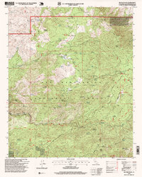
1996 Map of Butler Peak
USGS Topo · Published 1999About this map
San Bernardino National Forest terrain dominates this 1990s revision, revealing a landscape defined by rugged high-country peaks and scattered mining history. The map documents numerous mining interests such as the Balanced Rock Mine and several grouped claims including the Ironwood Group and Bench Camp Group. Settlement is sparse, represented by locations like Hawes Ranch and the Lake Arrowhead Scout Camps. Significant elevation shifts are marked by prominent summits like Butler Peak, Crafts Peak, and Rattlesnake Mountain. The transition between the high ridges of Redonda Ridge and the flatlands of Coyote Flat and Coxey Meadow illustrates the varied topography of this region. Notable recreational and navigational paths are identified, specifically the Pacific Crest National Scenic Trail, which traverses the southern portion of the sheet.
Find a feature on this map
71 named features on this map. Tap any name to fly to it.
Don’t see what you’re looking for? This feature index may not catch every label — zoom into the map to look around manually.
Map Details
Editions of this 1996 Butler Peak Map
This is the sole edition of this map. No revisions or reprints were ever made.
Other maps of this area

1899 · Redlands
USGS Topo · 1:62,500

1901 · Southern California Sheet No. 1
USGS Topo · 1:250,000

1901 · Redlands
USGS Topo · 1:62,500

1902 · Deep Creek
USGS Topo · 1:62,500

1902 · San Gorgonio
USGS Topo · 1:125,000

1904 · Southern California Sheet No. 1
USGS Topo · 1:250,000

1947 · Lucerne Valley
USGS Topo · 1:62,500

1949 · Lucerne Valley
USGS Topo · 1:62,500

1953 · San Bernardino
USGS Topo · 1:250,000
1953 · Harrison Mtn.
USGS Topo · 1:24,000