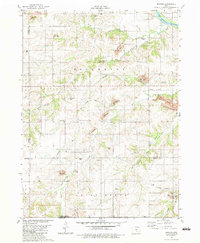
1982 Map of Buxton
USGS Topo · Published 1983About this map
The Des Moines River flows through the northeast corner of this Mahaska County landscape, while the interior is defined by an extensive history of coal extraction. In the early 1980s, large scars from Strip Mines mark the terrain near North Coal Creek and Bluff Creek. The settlement of Buxton and its associated Buxton Cem represent a significant local history, situated near an Old Railroad Grade that once served the region's industry. Genealogists will find numerous rural landmarks, including Weldon Cem, Pringle Cem, and the Union Liberty Ch. The map also details the Mine Shaft (Abandoned) in Jefferson township, underscoring the shift from underground to surface mining over time. Conservation areas like the Miami Lake State Game Management Area now occupy portions of this reworked industrial landscape.
Find a feature on this map
37 named features on this map. Tap any name to fly to it.
Don’t see what you’re looking for? This feature index may not catch every label — zoom into the map to look around manually.
Map Details
Editions of this 1982 Buxton Map
This is the sole edition of this map. No revisions or reprints were ever made.
Other maps of this area

1910 · Pella
USGS Topo · 1:62,500

1912 · Pella
USGS Topo · 1:62,500

1929 · Albia
USGS Topo · 1:62,500

1954 · Des Moines
USGS Topo · 1:250,000

1956 · Des Moines
USGS Topo · 1:250,000

1957 · Des Moines
USGS Topo · 1:250,000

1968 · Oskaloosa
USGS Topo · 1:24,000

1968 · Eddyville
USGS Topo · 1:24,000
1968 · Avery
USGS Topo · 1:24,000

1969 · Des Moines
USGS Topo · 1:250,000