
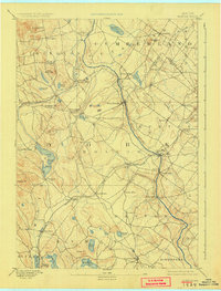
1892 Map of Buxton
USGS Topo · Published 1940About this map
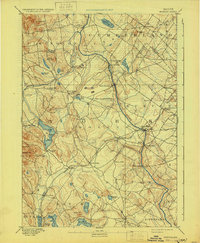
The Saco River serves as the industrial and geographic spine of this Maine landscape, powering a string of riverfront settlements including West Buxton, Bar Mills, Salmon Falls, and Union Falls. In the late nineteenth century, this waterway was essential for the timber and milling trades, evidenced by the clustered hamlets of Nasons Mills, Clarks Mills, and Goodwins Mills. In the southwest corner, the spiritual and agricultural enclave of Shaker Village sits near the shores of Shaker Pond, representing a distinct communal settlement pattern of the era. The region is well-connected by heavy rail, with the Maine Central and Boston and Maine railroads threading through the valleys. Upland terrain like Ossipee Hill and Crockett Hill rises above a network of smaller water bodies such as Watchic Pond and Little Ossipee Pond, where rural life centered on town hubs like Buxton Center and Hollis Center.
Find a feature on this map
62 named features on this map. Tap any name to fly to it.
Don’t see what you’re looking for? This feature index may not catch every label — zoom into the map to look around manually.
Map Details
Editions of this 1892 Buxton Map
4 editions found
Other maps of this area

1891 · Portland
USGS Topo · 1:62,500

1891 · Biddeford
USGS Topo · 1:62,500

1891 · Berwick
USGS Topo · 1:62,500

1891 · Kennebunk
USGS Topo · 1:62,500

1891 · Buxton
USGS Topo · 1:62,500

1891 · Newfield
USGS Topo · 1:62,500

1892 · Buxton
USGS Topo · 1:62,500

1893 · Kennebunk
USGS Topo · 1:62,500

1893 · Berwick
USGS Topo · 1:62,500

1893 · Biddeford
USGS Topo · 1:62,500