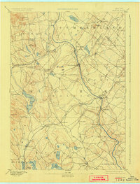
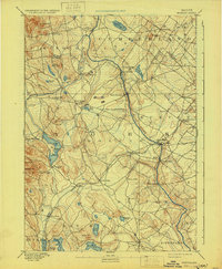
1892 Map of Buxton
USGS Topo · Published 1925About this map
The Saco River and Little Ossipee River dominate this late 19th-century landscape, providing the hydraulic power for a series of small industrial hamlets. Clusters of milling activity are evident at Nasons Mills, Salmon Falls, and Union Falls, where the river's descent toward the coast was harnessed by early manufacturers. This riverine economy is further illustrated by the presence of Clarks Mills and Goodwins Mills, which served as local processing hubs for the surrounding agricultural community.
Find a feature on this map
61 named features on this map. Tap any name to fly to it.
Don’t see what you’re looking for? This feature index may not catch every label — zoom into the map to look around manually.
Map Details
Editions of this 1892 Buxton Map
4 editions found

Other maps of this area

1891 · Portland
USGS Topo · 1:62,500

1891 · Biddeford
USGS Topo · 1:62,500

1891 · Berwick
USGS Topo · 1:62,500

1891 · Kennebunk
USGS Topo · 1:62,500

1891 · Buxton
USGS Topo · 1:62,500

1891 · Newfield
USGS Topo · 1:62,500

1892 · Buxton
USGS Topo · 1:62,500

1893 · Kennebunk
USGS Topo · 1:62,500

1893 · Berwick
USGS Topo · 1:62,500

1893 · Biddeford
USGS Topo · 1:62,500