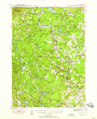
1942 Map of Buxton
USGS Topo · Published 1958About this map
The Saco River and Little River anchor the landscape of York and Cumberland counties in the years during World War II, serving as the power source for a dense network of riverside villages. Industrial activity is evident at Shaw Mills and through the various settlements like Salmon Falls and Bar Mills that line the riverbanks. The Boston and Maine railroad corridor cuts through the southeastern terrain, linking these mill towns to the broader regional economy. Away from the water, the map reveals a well-established rural social structure defined by family-named crossroads like Higgins Cor and Emory Cor, alongside numerous local schoolhouses such as Dearborn Sch and Emerson Sch. Genealogists may find particular value in the location of the Chadbourne Cem and the Notre Dame Institute near the southern boundary, providing a clear record of the area's mid-century community footprint before modern expansion.
Find a feature on this map
96 named features on this map. Tap any name to fly to it.
Don’t see what you’re looking for? This feature index may not catch every label — zoom into the map to look around manually.
Map Details
Editions of this 1942 Buxton Map
3 editions found
Other maps of this area

1891 · Portland
USGS Topo · 1:62,500

1891 · Biddeford
USGS Topo · 1:62,500

1891 · Berwick
USGS Topo · 1:62,500

1891 · Kennebunk
USGS Topo · 1:62,500

1891 · Buxton
USGS Topo · 1:62,500

1891 · Newfield
USGS Topo · 1:62,500

1892 · Buxton
USGS Topo · 1:62,500

1893 · Kennebunk
USGS Topo · 1:62,500

1893 · Berwick
USGS Topo · 1:62,500

1893 · Biddeford
USGS Topo · 1:62,500