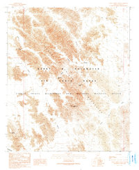
1990 Map of Cabeza Prieta Peak
USGS Topo · Published 1990About this map
The Cabeza Prieta Mountains dominate this 1990 provisional survey, where the overlapping jurisdictions of conservation and military aviation meet in the Sonoran Desert. Centered on the 2,592-foot summit of Cabeza Prieta Peak, the map documents a landscape defined by restricted access and vital water catchments such as Halfway Tank and Cabeza Prieta Tanks. The terrain is divided between the Barry M Goldwater Air Force Range and the Cabeza Prieta Wilderness and National Wildlife Refuge, illustrating the dual use of these desert reaches for both tactical training and environmental preservation. Notable topographic features include the A-1 Basin and Surprise Canyon, while the southern portion of the sheet is marked by Tordillo Mountain. This edition reflects the meticulous field checks and aerial revisions of the late 20th century, tracing the narrow transit points like Cabeza Prieta Pass used by those navigating this arid corridor.
Find a feature on this map
15 named features on this map. Tap any name to fly to it.
Don’t see what you’re looking for? This feature index may not catch every label — zoom into the map to look around manually.
Map Details
Editions of this 1990 Cabeza Prieta Peak Map
This is the sole edition of this map. No revisions or reprints were ever made.
Other maps of this area

1953 · Ajo
USGS Topo · 1:250,000

1957 · Ajo
USGS Topo · 1:250,000

1958 · Ajo
USGS Topo · 1:250,000

1962 · Ajo
USGS Topo · 1:250,000

1963 · Ajo
USGS Topo · 1:250,000

1965 · Cabeza Prieta Peak
USGS Topo · 1:62,500
1965 · Tule Mountains
USGS Topo · 1:62,500

1965 · Isla Pinta
USGS Topo · 1:62,500

1965 · Sierra Arida
USGS Topo · 1:62,500

1967 · Ajo
USGS Topo · 1:250,000