
1965 Map of Isla Pinta
USGS Topo · Published 1966About this map
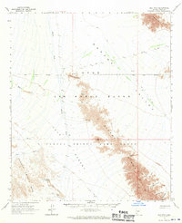
Mohawk Valley and the Tule Desert dominate this mid-century desert landscape, where the arid environment is defined by expansive washes and jagged mountain ranges. Large portions of the territory are managed as the Luke Air Force Range and the Cabeza Prieta Game Range, highlighting the shift toward federal conservation and military use in the Yuma region. The rugged spine of the Sierra Pinta cuts through the center of the sheet, featuring named crossings such as Bean Pass and Sunday Pass. Traces of human activity are sparse, consisting primarily of isolated water sources like Sahara Tank and Isla Pinta, alongside a few unnamed prospects and a network of jeep trails. To the southwest, the Cabeza Prieta Mts rise from the desert floor, with Christmas Pass providing a named point of transit between the peaks.
Find a feature on this map
30 named features on this map. Tap any name to fly to it.
Don’t see what you’re looking for? This feature index may not catch every label — zoom into the map to look around manually.
Map Details
Editions of this 1965 Isla Pinta Map
2 editions found
Other maps of this area

1926 · Mohawk
USGS Topo · 1:62,500

1927 · Aguila Mountains
USGS Topo · 1:48,000

1927 · Kim
USGS Topo · 1:62,500

1928 · Mohawk
USGS Topo · 1:62,500

1930 · Aguila Mountains
USGS Topo · 1:62,500

1931 · Kim
USGS Topo · 1:62,500

1953 · Ajo
USGS Topo · 1:250,000

1957 · Ajo
USGS Topo · 1:250,000

1958 · Ajo
USGS Topo · 1:250,000

1962 · Ajo
USGS Topo · 1:250,000