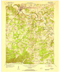
1953 Map of Cadiz
USGS Topo · Published 1955About this map
The Little River winds through the heart of this Trigg County landscape, defining the layout of Cadiz and the surrounding agricultural tracts. This early 1950s survey documents a rural economy still tightly connected to the river and the Cadiz RR, which serves the town center near the Jeff Davis Highway. The map is particularly rich in genealogical data, preserving the locations of numerous family burial grounds such as Miller Cem, Wallace Cem, and Peyton-Thomas Cem scattered across the hills.
Find a feature on this map
46 named features on this map. Tap any name to fly to it.
Don’t see what you’re looking for? This feature index may not catch every label — zoom into the map to look around manually.
Map Details
Editions of this 1953 Cadiz Map
This is the sole edition of this map. No revisions or reprints were ever made.
Other maps of this area

1950 · Caledonia
USGS Topo · 1:24,000

1951 · Caledonia
USGS Topo · 1:24,000

1951 · Model
USGS Topo · 1:24,000

1951 · Roaring Spring
USGS Topo · 1:24,000

1951 · Johnson Hollow
USGS Topo · 1:24,000

1953 · Canton
USGS Topo · 1:24,000

1953 · Gracey
USGS Topo · 1:24,000

1953 · Cobb
USGS Topo · 1:24,000
1953 · Lamasco
USGS Topo · 1:24,000

1956 · Nashville
USGS Topo · 1:250,000