
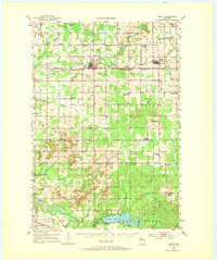
1952 Map of Cadott
USGS Topo · Published 1954About this map
The Yellow River and the Minneapolis St Paul and Sault Ste Marie railroad corridor define the settlement patterns of central Wisconsin in the early 1950s. The village of Cadott serves as a primary hub, surrounded by a dense network of rural one-room schoolhouses such as Baker Sch, Progressive Sch, and McKinley Sch. Further east, the town of Boyd anchors the township of Delmar.
Find a feature on this map
71 named features on this map. Tap any name to fly to it.
Don’t see what you’re looking for? This feature index may not catch every label — zoom into the map to look around manually.
Map Details
Editions of this 1952 Cadott Map
2 editions found
Other maps of this area

1927 · Strum
USGS Topo · 1:62,500

1930 · Strum
USGS Topo · 1:62,500

1934 · Chippewa Falls
USGS Topo · 1:62,500

1935 · Osseo
USGS Topo · 1:48,000

1936 · Chippewa Falls
USGS Topo · 1:62,500

1940 · Osseo
USGS Topo · 1:62,500

1948 · Fairchild
USGS Topo · 1:62,500

1949 · Fairchild
USGS Topo · 1:62,500

1949 · Bloomer
USGS Topo · 1:62,500

1951 · Bloomer
USGS Topo · 1:62,500