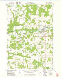
1979 Map of Cadott
USGS Topo · Published 1980About this map
The Yellow River winds through the heart of this central Wisconsin landscape, anchoring the village of Cadott as it appeared in the late 1970s. The village is characterized by a mix of community landmarks like Riverview Park and the Brooklawn Cem, while the surrounding townships of Anson, Goetz, Lafayette, and Sigel maintain a predominantly rural character. This period reflects a mature agricultural and residential network, defined by a grid of named local routes such as Stillson Road and Lafayette Drive.
Find a feature on this map
34 named features on this map. Tap any name to fly to it.
Don’t see what you’re looking for? This feature index may not catch every label — zoom into the map to look around manually.
Map Details
Editions of this 1979 Cadott Map
This is the sole edition of this map. No revisions or reprints were ever made.
Other maps of this area

1934 · Chippewa Falls
USGS Topo · 1:62,500

1936 · Chippewa Falls
USGS Topo · 1:62,500

1949 · Bloomer
USGS Topo · 1:62,500

1951 · Bloomer
USGS Topo · 1:62,500

1951 · Cornell
USGS Topo · 1:62,500

1952 · Cadott
USGS Topo · 1:62,500

1953 · Eau Claire
USGS Topo · 1:250,000

1953 · Rice Lake
USGS Topo · 1:250,000

1958 · Eau Claire
USGS Topo · 1:250,000

1959 · Rice Lake
USGS Topo · 1:250,000