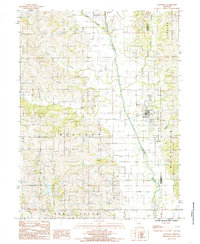
1984 Map of Cainsville
USGS Topo · Published 1985About this map
Thompson River dictates the landscape of northern Missouri in this mid-1980s survey, winding south through the center of the quadrangle. The town of Cainsville serves as the primary hub of activity, situated where the river valley widens near the confluence with Brushy Creek. This era of the Missouri-Iowa borderlands is defined by a dense network of drainage, with smaller tributaries like Coal Creek, Donaby Creek, and Little Panther Creek carving through the agricultural townships of Clay, Madison, and Trail Creek. The map provides specific location data for genealogists, including a local Cem near the river, while tracing the county line where Harrison and Mercer Counties meet. The terrain remains largely divided into large tracts, reflecting the enduring rural character of Harrison County during this period.
Find a feature on this map
16 named features on this map. Tap any name to fly to it.
Don’t see what you’re looking for? This feature index may not catch every label — zoom into the map to look around manually.
Map Details
Editions of this 1984 Cainsville Map
This is the sole edition of this map. No revisions or reprints were ever made.
Other maps of this area

1945 · Lamoni
USGS Topo · 1:62,500

1946 · Princeton
USGS Topo · 1:62,500

1947 · Lamoni
USGS Topo · 1:62,500

1947 · Blythedale
USGS Topo · 1:62,500

1948 · Princeton
USGS Topo · 1:62,500

1954 · Centerville
USGS Topo · 1:250,000

1957 · Centerville
USGS Topo · 1:250,000

1958 · Centerville
USGS Topo · 1:250,000

1964 · Pleasanton
USGS Topo · 1:24,000
1981 · Lamoni South
USGS Topo · 1:24,000