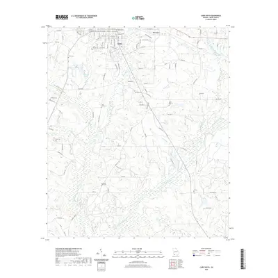
2020 Map of Cairo South
USGS Topo · Published 2020About this map
Cairo dominates the northern edge of this Grady County landscape, with its residential streets transitioning into the rural drainage basins of the Ochlockonee River. The area is notably dense with family and community burial grounds, serving as a significant record for genealogical research. Sites such as Cairo City Cem, Myrtle Hill Cem, and Centennial Church Cem are distributed across the terrain, reflecting established settlement patterns. The hydrology of the region is defined by the winding Ochlockonee River and its various tributaries, including Tired Cr and Brumbley Creek. South of the city center, the map reveals a network of country roads such as Calvary Rd SW and Pine Park Rd that connect isolated landmarks like the Lewis Memorial Cem and White Springs Cem.
Find a feature on this map
101 named features on this map. Tap any name to fly to it.
Don’t see what you’re looking for? This feature index may not catch every label — zoom into the map to look around manually.
Map Details
Editions of this 2020 Cairo South Map
This is the sole edition of this map. No revisions or reprints were ever made.
Other maps of this area

1954 · Tallahassee
USGS Topo · 1:250,000

1955 · Whigham
USGS Topo · 1:62,500

1956 · Cairo
USGS Topo · 1:62,500

1956 · Calvary
USGS Topo · 1:24,000

1957 · Beachton
USGS Topo · 1:24,000

1957 · Miccosukee NE
USGS Topo · 1:24,000

1959 · Tallahassee
USGS Topo · 1:250,000

1960 · Tallahassee
USGS Topo · 1:250,000
1974 · Pine Park
USGS Topo · 1:24,000
1974 · Whigham
USGS Topo · 1:24,000