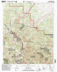
1996 Map of Cajon
USGS Topo · Published 1999About this map
The San Andreas Fault Zone carves a dramatic geological path through this portion of the San Bernardino National Forest, dictating the alignment of the region's primary transportation corridors. This 1996 revision shows the critical junction where the Santa Fe and Southern Pacific railroads navigate the steep ascent toward Cajon Summit. The map details the complex infrastructure required for this mountain passage, including the Cajon Guard Station and a high-altitude Weighing Station near Cajon Junction.
Find a feature on this map
40 named features on this map. Tap any name to fly to it.
Don’t see what you’re looking for? This feature index may not catch every label — zoom into the map to look around manually.
Map Details
Editions of this 1996 Cajon Map
This is the sole edition of this map. No revisions or reprints were ever made.
Other maps of this area

1896 · San Bernardino
USGS Topo · 1:62,500

1897 · Cucamonga
USGS Topo · 1:62,500

1898 · San Bernardino
USGS Topo · 1:62,500

1900 · Cucamonga
USGS Topo · 1:62,500

1901 · Southern California Sheet No. 1
USGS Topo · 1:250,000

1901 · San Bernardino
USGS Topo · 1:62,500

1902 · Hesperia
USGS Topo · 1:62,500

1903 · Cucamonga
USGS Topo · 1:62,500

1903 · San Antonio
USGS Topo · 1:62,500

1904 · Southern California Sheet No. 1
USGS Topo · 1:250,000