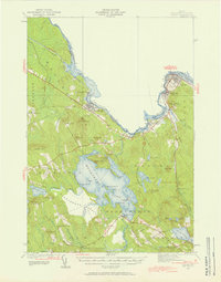
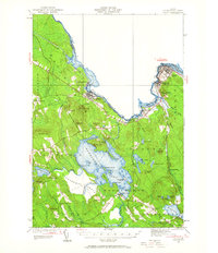
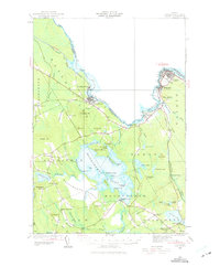
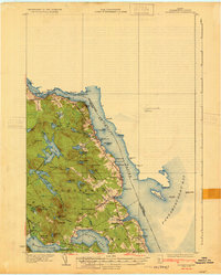
1929 Map of Calais
USGS Topo · Published 1957About this map
The St Croix River forms a jagged international boundary through this 1929 survey, connecting the industrial nodes of Calais and Milltown with the mills of Woodland. The landscape is defined by the heavy rail infrastructure of the Maine Central railroad, which links riverside settlements through junctions like Woodland Junc and St Croix Junc. To the south, the massive expanse of Meddybemps Lake and the Meddybemps Heath dominate the terrain, surrounded by a network of rural schools including the North Union Sch and Damon Sch. The map reveals a region built on the intersection of timber, water power, and cross-border transport, where smaller settlements like Baring and Alexander occupy the spaces between the highland peaks of Staples Mtn and Pineo Mtn.
Find a feature on this map
76 named features on this map. Tap any name to fly to it.
Don’t see what you’re looking for? This feature index may not catch every label — zoom into the map to look around manually.
Map Details
Editions of this 1929 Calais Map
4 editions found
Other maps of this area

1907 · Eastport
USGS Topo · 1:48,000

1908 · Eastport
USGS Topo · 1:62,500

1929 · Calais
USGS Topo · 1:48,000
1929 · Robbinston
USGS Topo · 1:48,000
1931 · Robbinston
USGS Topo · 1:62,500

1932 · Calais
USGS Topo · 1:62,500

1940 · Waite
USGS Topo · 1:62,500
1940 · Kellyland
USGS Topo · 1:62,500
1941 · Wesley
USGS Topo · 1:62,500

1941 · Gardner Lake
USGS Topo · 1:62,500