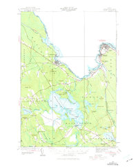
1929 Map of Calais
USGS Topo · Published 1975About this map
The St Croix River defines the international boundary between Maine and New Brunswick in this 1929 survey, illustrating the industrial and transport landscape of eastern Washington County. The Maine Central railroad network is central to the region's economy, linking timber and milling centers like Woodland and Milltown through vital hubs such as Woodland Junc and St Croix Junc. Further south, the expansive Meddybemps Lake is surrounded by a patchwork of rural life, including the Meddybemps Heath and several small settlements like Alexander and Meddybemps.
Find a feature on this map
82 named features on this map. Tap any name to fly to it.
Don’t see what you’re looking for? This feature index may not catch every label — zoom into the map to look around manually.
Map Details
Editions of this 1929 Calais Map
4 editions found
Other maps of this area

1907 · Eastport
USGS Topo · 1:48,000

1908 · Eastport
USGS Topo · 1:62,500

1929 · Calais
USGS Topo · 1:48,000

1929 · Robbinston
USGS Topo · 1:48,000

1931 · Robbinston
USGS Topo · 1:62,500

1932 · Calais
USGS Topo · 1:62,500

1940 · Waite
USGS Topo · 1:62,500

1940 · Kellyland
USGS Topo · 1:62,500

1941 · Wesley
USGS Topo · 1:62,500

1941 · Gardner Lake
USGS Topo · 1:62,500