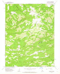
1962 Map of Calaveritas
USGS Topo · Published 1963About this map
Calaveritas sits at the heart of this gold country landscape, where the terrain is marked by the heavy influence of 19th-century mining and mid-20th-century ranching. The map reveals a high concentration of resource extraction history, from the Starlite Mine and Sunset Mine to the Thomas Bros Mine near Cave City. This area of the Sierra Nevada foothills is defined by complex drainage systems like San Antonio Creek and Calaveritas Creek, which historically supported hydraulic and quartz mining operations.
Find a feature on this map
2 named features on this map. Tap any name to fly to it.
Don’t see what you’re looking for? This feature index may not catch every label — zoom into the map to look around manually.
Map Details
Editions of this 1962 Calaveritas Map
3 editions found
Other maps of this area

1889 · Jackson
USGS Topo · 1:125,000

1891 · Big Trees
USGS Topo · 1:125,000

1892 · Jackson
USGS Topo · 1:125,000

1894 · Big Trees
USGS Topo · 1:125,000

1897 · Jackson
USGS Topo · 1:125,000

1897 · Big Trees
USGS Topo · 1:125,000

1901 · Big Trees
USGS Topo · 1:125,000

1902 · Jackson
USGS Topo · 1:125,000

1945 · San Andreas
USGS Topo · 1:62,500

1947 · San Andreas
USGS Topo · 1:62,500