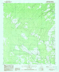
1988 Map of Calfpen Bay
USGS Topo · Published 1988About this map
The settlement of Gillisonville anchors this survey of Jasper County, characterized by the expansive hydrological network of the Lowcountry. The landscape is dominated by large wetland features such as Calfpen Bay and Poli Bay, which are intersected by watercourses like Beaverdam Branch and Gillison Branch. This environment is shaped by a series of Levees and drainage systems that feed into the Great Swamp, reflecting the region's historical management of its water-rich terrain. Beyond the main crossroads, the map identifies localized landmarks including a Lookout Tower, a small Cem for genealogical interest, and a terrain feature known as Little Rock. The presence of Buck Drive indicates the rural road development connecting these isolated bays and branches in the late twentieth century.
Find a feature on this map
12 named features on this map. Tap any name to fly to it.
Don’t see what you’re looking for? This feature index may not catch every label — zoom into the map to look around manually.
Map Details
Editions of this 1988 Calfpen Bay Map
This is the sole edition of this map. No revisions or reprints were ever made.
Other maps of this area

1918 · Yemassee
USGS Topo · 1:62,500

1919 · Pineland
USGS Topo · 1:62,500

1920 · Hardeeville
USGS Topo · 1:62,500

1920 · Okatie
USGS Topo · 1:62,500

1942 · Okatie
USGS Topo · 1:62,500

1943 · Pineland
USGS Topo · 1:62,500

1943 · Hardeeville
USGS Topo · 1:62,500

1943 · Yemassee
USGS Topo · 1:62,500

1947 · Savannah
USGS Topo · 1:250,000

1948 · Savannah
USGS Topo · 1:250,000