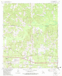
1982 Map of Calhoun
USGS Topo · Published 1982About this map
Calhoun serves as the primary hub of this north Louisiana landscape, characterized by the sprawling Calhoun Gas and Oil Field and the Illinois Central Gulf railroad line. The settlement pattern is defined by family-named routes and rural junctions, such as Eureka and Carlton, which supported the region’s agricultural and petroleum interests. The North Louisiana Experimental Station stands as a notable landmark of the local land-grant research history, while the northern reaches include the Ouachita Valley Council Scout Reservation and a portion of the D'Arbonne National Wildlife Refuge. Numerous country churches and family burial grounds, including Aulds Chapel, Spillers Cem, and Mt Zion Cem, are scattered throughout the piney woods, offering valuable locations for genealogical research and local history studies in Ouachita Parish during the early 1980s.
Find a feature on this map
65 named features on this map. Tap any name to fly to it.
Don’t see what you’re looking for? This feature index may not catch every label — zoom into the map to look around manually.
Map Details
Editions of this 1982 Calhoun Map
This is the sole edition of this map. No revisions or reprints were ever made.
Other maps of this area

1935 · Drew
USGS Topo · 1:62,500

1940 · Monroe
USGS Topo · 1:62,500

1952 · Calhoun
USGS Topo · 1:62,500

1953 · Chatham
USGS Topo · 1:62,500

1955 · Shreveport
USGS Topo · 1:250,000

1956 · Shreveport
USGS Topo · 1:250,000

1957 · Monroe North
USGS Topo · 1:62,500

1957 · West Monroe North
USGS Topo · 1:24,000

1957 · West Monroe South
USGS Topo · 1:24,000

1957 · Monroe South
USGS Topo · 1:62,500