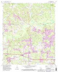
1994 Map of Calhoun
USGS Topo · Published 1995About this map
The Calhoun Gas and Oil Field anchors the southern portion of this landscape, reflecting the deep integration of energy extraction into the rural economy of Ouachita Parish during the mid-to-late 20th century. The settlement of Calhoun serves as a local hub, flanked by the North Louisiana Experimental Station and significant community sites like Roselawn Memorial Gardens. This map, updated in the 1990s, documents a transition from purely agricultural uses to recreational and conservation-focused lands, seen in the Quachita Valley Council Scout Reservation and the edge of the D'Arbonne National Wildlife Refuge. Numerous small community anchors, such as Aulds Chapel, Liberty Ch, and Spring Hill Ch, are linked by a dense network of local routes like Sims Road and Golson Road, while the winding Bayou Choudrant and Cheniere Creek define the underlying drainage of the region.
Find a feature on this map
66 named features on this map. Tap any name to fly to it.
Don’t see what you’re looking for? This feature index may not catch every label — zoom into the map to look around manually.
Map Details
Editions of this 1994 Calhoun Map
This is the sole edition of this map. No revisions or reprints were ever made.
Other maps of this area

1935 · Drew
USGS Topo · 1:62,500

1940 · Monroe
USGS Topo · 1:62,500

1952 · Calhoun
USGS Topo · 1:62,500

1953 · Chatham
USGS Topo · 1:62,500

1955 · Shreveport
USGS Topo · 1:250,000

1956 · Shreveport
USGS Topo · 1:250,000

1957 · Monroe North
USGS Topo · 1:62,500

1957 · West Monroe North
USGS Topo · 1:24,000

1957 · West Monroe South
USGS Topo · 1:24,000

1957 · Monroe South
USGS Topo · 1:62,500