
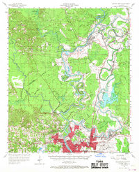
1957 Map of Monroe North
USGS Topo · Published 1958About this map
The Quachita River meanders through this mid-century landscape, defining the development patterns of Monroe and West Monroe. The riparian environment is heavily detailed with oxbows and backwaters like Horseshoe Lake and Cotton Patch Lake, while the vast Black Bayou Lake dominates the eastern wetlands. Industrial and infrastructure growth is evident through the presence of the Gulf Asphalt Field and the sprawling Selman Airport grounds.
Find a feature on this map
90 named features on this map. Tap any name to fly to it.
Don’t see what you’re looking for? This feature index may not catch every label — zoom into the map to look around manually.
Map Details
Editions of this 1957 Monroe North Map
2 editions found
Other maps of this area

1935 · Collinston
USGS Topo · 1:62,500

1935 · Naff
USGS Topo · 1:62,500

1935 · Alto
USGS Topo · 1:62,500

1935 · Drew
USGS Topo · 1:62,500

1935 · Haile
USGS Topo · 1:62,500

1940 · Monroe
USGS Topo · 1:62,500

1952 · Calhoun
USGS Topo · 1:62,500

1952 · Farmerville
USGS Topo · 1:62,500

1953 · Chatham
USGS Topo · 1:62,500

1955 · Jackson
USGS Topo · 1:250,000