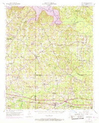
1952 Map of Calhoun
USGS Topo · Published 1969About this map
Downsville and the surrounding piney hills of north-central Louisiana appear at a moment of transition, as the Bayou D'arbonne Lake reservoir begins to define the northern landscape. The map reveals a dense network of family-named cemeteries and rural churches such as Acree Cem and Auld Chapel, documenting the genealogical fabric of Lincoln, Union, and Ouachita Parishes. The southern portion of the sheet is dominated by the industrial infrastructure of the Tremont Gas Field and the Illinois Central railroad, which passes through the town of Tremont. For those tracing local history, the map preserves the location of the Arbonne Lookout Tower and smaller rural institutions like Millard Hill Sch and Lane Sch. The inclusion of an Old Railroad Grade alongside newer pipeline routes provides a clear picture of how transportation and energy sectors evolved in this part of the state during the mid-20th century.
Find a feature on this map
76 named features on this map. Tap any name to fly to it.
Don’t see what you’re looking for? This feature index may not catch every label — zoom into the map to look around manually.
Map Details
Editions of this 1952 Calhoun Map
3 editions found
Other maps of this area

1935 · Drew
USGS Topo · 1:62,500

1935 · Haile
USGS Topo · 1:62,500

1940 · Monroe
USGS Topo · 1:62,500

1950 · Ruston
USGS Topo · 1:62,500

1951 · Ruston
USGS Topo · 1:62,500

1951 · Bernice
USGS Topo · 1:62,500

1952 · Calhoun
USGS Topo · 1:62,500

1952 · Farmerville
USGS Topo · 1:62,500

1953 · Chatham
USGS Topo · 1:62,500

1953 · Hodge
USGS Topo · 1:62,500