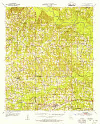
1952 Map of Calhoun
USGS Topo · Published 1956About this map
Calhoun and the surrounding piney woods of northern Louisiana are captured here during a period of steady rural development in the early 1950s. The southern portion of the sheet is dominated by the Illinois Central railroad corridor, which links the settlements of Tremont and Calhoun, the latter featuring an Experiment Station and the Jerusalem Ch. Northward, the landscape transitions into a dense network of hills and drainages like Choudrant Bayou and Bayou D'Arbonne. This area is dotted with numerous family-centered landmarks and community hubs, including Holmesville Ch and the Cedar Grove Cem.
Find a feature on this map
69 named features on this map. Tap any name to fly to it.
Don’t see what you’re looking for? This feature index may not catch every label — zoom into the map to look around manually.
Map Details
Editions of this 1952 Calhoun Map
3 editions found
Other maps of this area

1935 · Drew
USGS Topo · 1:62,500

1935 · Haile
USGS Topo · 1:62,500

1940 · Monroe
USGS Topo · 1:62,500

1950 · Ruston
USGS Topo · 1:62,500

1951 · Ruston
USGS Topo · 1:62,500

1951 · Bernice
USGS Topo · 1:62,500

1952 · Calhoun
USGS Topo · 1:62,500

1952 · Farmerville
USGS Topo · 1:62,500

1953 · Chatham
USGS Topo · 1:62,500

1953 · Hodge
USGS Topo · 1:62,500