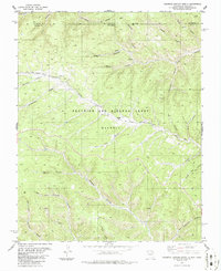
1986 Map of Caliente Canyon North
USGS Topo · Published 1986About this map
The Beaubien and Miranda Grant (Maxwell) dominates this high-altitude landscape along the border of Colorado and New Mexico in the mid-1980s. A ghost of early industrial presence is visible at Catskill (Site), where an Old Railroad Grade follows the winding path of the Canadian River. This corridor reflects a time when timber or mining spurred rail development into these complex drainages. The area is defined by a dense network of named canyons, including Caliente Canyon, Stubblefield Canyon, and Frankies Canyon. Evidence of land management and early ranching persists through features like a Windmill, a Cemetery north of Catskill, and the Commissary Tub Canyon. The map records a transition from active settlement to a more isolated, managed territory under the historic land grant.
Find a feature on this map
32 named features on this map. Tap any name to fly to it.
Don’t see what you’re looking for? This feature index may not catch every label — zoom into the map to look around manually.
Map Details
Editions of this 1986 Caliente Canyon North Map
This is the sole edition of this map. No revisions or reprints were ever made.
Other maps of this area

1891 · Spanish Peaks
USGS Topo · 1:125,000

1893 · Spanish Peaks
USGS Topo · 1:125,000

1895 · Spanish Peaks
USGS Topo · 1:125,000

1897 · Spanish Peaks
USGS Topo · 1:125,000

1900 · Spanish Peaks
USGS Topo · 1:125,000

1915 · Brilliant
USGS Topo · 1:62,500

1951 · Valdez
USGS Topo · 1:24,000

1954 · Raton
USGS Topo · 1:250,000

1954 · Trinidad
USGS Topo · 1:250,000

1955 · Trinidad
USGS Topo · 1:250,000