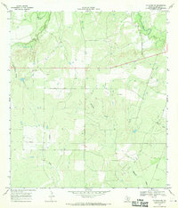
1967 Map of Calliham NW
USGS Topo · Published 1970About this map
The Dragoon Oil And Gas Field defines much of the southern landscape of this McMullen County quadrangle in the late 1960s, reflecting the region's mid-century energy production. Several Pipeline routes and scattered oil wells punctuate the brush country, illustrating the industrial infrastructure that overlays the natural drainage basins. The Frio River winds through the northern portion of the map, fed by tributaries like Salt Branch, while the central and southern terrain is carved by Dragoon Creek and Dragoon Hollow. Evidence of small-scale extraction is visible at various Gravel Pit locations near Landers, a solitary named settlement hub in a region primarily dedicated to ranching and resource recovery. This survey captures a specific moment when traditional Texas land use intersected with an intensifying search for subterranean wealth in the South Texas plains.
Find a feature on this map
13 named features on this map. Tap any name to fly to it.
Don’t see what you’re looking for? This feature index may not catch every label — zoom into the map to look around manually.
Map Details
Editions of this 1967 Calliham NW Map
This is the sole edition of this map. No revisions or reprints were ever made.
Other maps of this area

1920 · Mikeska
USGS Topo · 1:125,000

1925 · Simmons No. 1
USGS Topo · 1:48,000

1925 · Tilden No. 1
USGS Topo · 1:48,000

1925 · Crowther No. 3
USGS Topo · 1:48,000

1925 · Simmons No. 2
USGS Topo · 1:48,000

1929 · Simmons
USGS Topo · 1:62,500

1930 · Tilden
USGS Topo · 1:62,500

1930 · Whitsett
USGS Topo · 1:62,500

1942 · Tilden
USGS Topo · 1:62,500

1942 · Whitsett
USGS Topo · 1:62,500