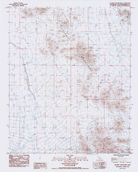
1985 Map of Calumet Mountains
USGS Topo · Published 1985About this map
The Calumet Mountains dominate this 1980s landscape, providing a clear view of the high desert topography in San Bernardino County. This provisional survey captures the transition from the steep, rocky slopes of the mountains down into the expansive Cadiz Valley to the east. The terrain is marked by intricate drainage patterns and isolated Sand Dunes that have accumulated along the valley floor. While the area is largely uninhabited, the presence of numerous bench marks and vertical flight benchmarks, such as BM 202.1 and Vfbo-F 3-99, indicates the intensity of geodetic survey work required to map this arid corner of the Mojave Desert. The map serves as a precise record of the landforms and elevation changes defining this part of the California interior during the mid-1980s.
Find a feature on this map
33 named features on this map. Tap any name to fly to it.
Don’t see what you’re looking for? This feature index may not catch every label — zoom into the map to look around manually.
Map Details
Editions of this 1985 Calumet Mountains Map
This is the sole edition of this map. No revisions or reprints were ever made.
Other maps of this area

1942 · Amboy
USGS Topo · 1:250,000

1943 · Amboy
USGS Topo · 1:250,000

1943 · Cadiz Lake
USGS Topo · 1:62,500

1943 · Cadiz Valley
USGS Topo · 1:62,500

1954 · Needles
USGS Topo · 1:250,000

1954 · Bristol Lake NW
USGS Topo · 1:24,000

1954 · Bristol Lake SW
USGS Topo · 1:24,000

1956 · Needles
USGS Topo · 1:250,000

1956 · Dale Lake
USGS Topo · 1:62,500

1956 · Bristol Lake
USGS Topo · 1:62,500