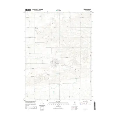
2015 Map of Cambridge
USGS Topo · Published 2015About this map
Cambridge serves as the central hub of this Henry County landscape, situated at the intersection of a grid-iron road network and surrounded by a series of significant local burial grounds. The geographic distribution of Grace Episcopal Cem, Munson Cem, Rose Dale Cem, Talbot Cem, and McHay Cem suggests a long-standing pattern of family and community-based land ownership throughout the township.
Find a feature on this map
45 named features on this map. Tap any name to fly to it.
Don’t see what you’re looking for? This feature index may not catch every label — zoom into the map to look around manually.
Map Details
Editions of this 2015 Cambridge Map
This is the sole edition of this map. No revisions or reprints were ever made.
Other maps of this area

1931 · Galva
USGS Topo · 1:48,000

1934 · Geneseo
USGS Topo · 1:62,500

1937 · Orion
USGS Topo · 1:62,500

1940 · Galva
USGS Topo · 1:62,500

1944 · Galva
USGS Topo · 1:62,500

1947 · Woodhull
USGS Topo · 1:62,500

1953 · Nekoma
USGS Topo · 1:24,000

1953 · Woodhull
USGS Topo · 1:24,000

1953 · German Corner
USGS Topo · 1:24,000
1953 · Geneseo
USGS Topo · 1:24,000