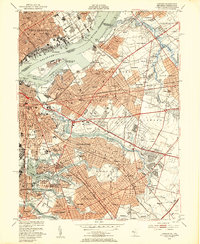
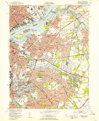
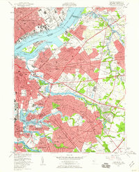
1949 Map of Camden
USGS Topo · Published 1953About this map
The Delaware River defines the industrial and urban character of this mid-century survey, separating Philadelphia from the dense suburban expansion of Camden. Along the waterfront, active shipping and transit infrastructure are evident, from the Tacony-Palmyra Bridge to the many wrecks and dolphins lining the channel around Petty Island. This era captures a landscape in transition, where established neighborhoods like Merchantville and Collingswood meet newer developments such as Erlton.
Find a feature on this map
117 named features on this map. Tap any name to fly to it.
Don’t see what you’re looking for? This feature index may not catch every label — zoom into the map to look around manually.
Map Details
Editions of this 1949 Camden Map
3 editions found
Other maps of this area

1888 · Mount Holly
USGS Topo · 1:62,500

1890 · Burlington
USGS Topo · 1:62,500

1891 · Philadelphia
USGS Topo · 1:62,500

1893 · Germantown
USGS Topo · 1:62,500

1893 · Burlington
USGS Topo · 1:62,500

1894 · Mount Holly
USGS Topo · 1:62,500

1894 · Philadelphia
USGS Topo · 1:62,500

1894 · Germantown
USGS Topo · 1:62,500

1896 · Germantown
USGS Topo · 1:62,500

1896 · Philadelphia
USGS Topo · 1:62,500