
1935 Map of Camden
USGS Topo · Published 1935About this map
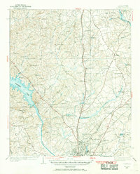
The Wateree River basin in the mid-1930s reveals a landscape of established mill ponds and agricultural communities transitioning toward modern industry. At the southern edge of the map, Camden serves as the regional hub, its street grid organized near the Southern Railway and Seaboard Air Line corridors. This survey, compiled from early aerial photography by the Air Corps, provides a distinct record of the era's land use, from the Camden Landing Field to the Lockhart Oil Field in the northeast. Numerous local landmarks define the social geography, including the Baron de Kalb Sch and a series of rural houses of worship such as Sanders Creek Ch and Bingham Chapel. Water power and control are evident through features like the Hermitage Mill Pond and Colonial Lake, while the Prison Camp near Lake Shamokin adds a specific institutional layer to this Depression-era South Carolina landscape.
Find a feature on this map
63 named features on this map. Tap any name to fly to it.
Don’t see what you’re looking for? This feature index may not catch every label — zoom into the map to look around manually.
Map Details
Editions of this 1935 Camden Map
2 editions found
Other maps of this area

1935 · Killian
USGS Topo · 1:48,000

1937 · Killian
USGS Topo · 1:62,500

1938 · Camden
USGS Topo · 1:62,500

1938 · Hagood
USGS Topo · 1:62,500

1941 · Spartanburg
USGS Topo · 1:250,000

1942 · Camden
USGS Topo · 1:125,000

1953 · Camden South
USGS Topo · 1:24,000

1953 · Lugoff
USGS Topo · 1:24,000

1953 · Blaney
USGS Topo · 1:24,000

1953 · Spartanburg
USGS Topo · 1:250,000